Analysis of the Distribution Characteristics and Driving Factors of Cultural Resources in the Yangtze River Basin Based on the GeoDetector Model
Keywords:
Multimodal Interaction; Mental Health Monitoring; Personalized Intervention; Context Awareness; College StudentsAbstract
The Yangtze River Basin is a significant region for China's traditional cultural resources, hosting numerous traditional villages and intangible cultural heritage. However, with the rapid development of regional economies and the acceleration of urbanization, the cultural resources in the Yangtze River Basin are facing severe protection challenges, such as environmental degradation, resource development pressure, and changes in social structure. To address these issues, this study proposes a comprehensive analysis of the spatial distribution characteristics and driving factors of traditional villages and intangible cultural heritage within a unified framework, aimed at revealing their distribution patterns and influencing mechanisms in the Yangtze River Basin.
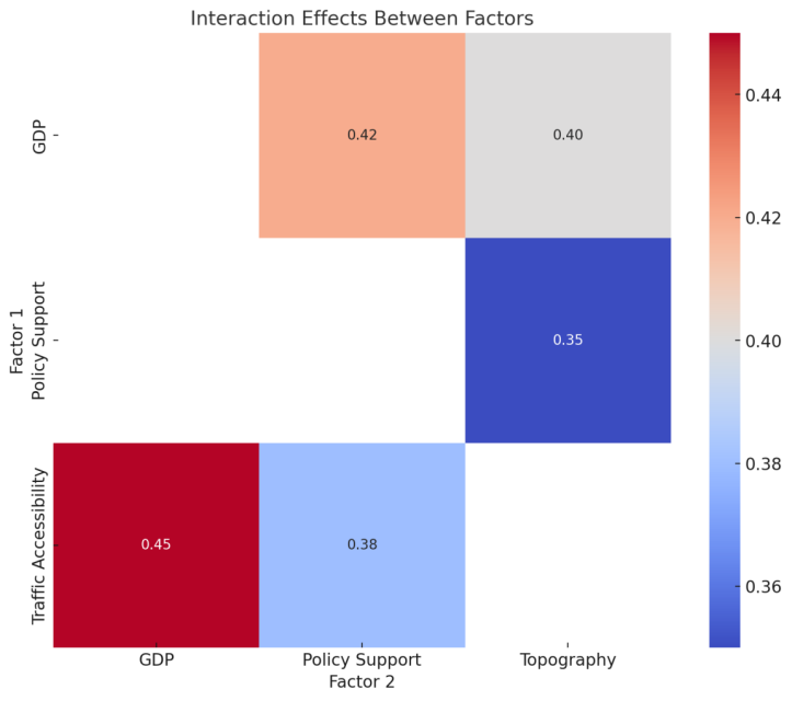
This study integrates spatial analysis, the GeoDetector model, and the Minimum Cumulative Resistance (MCR) model. First, based on kernel density and standard deviation ellipse analysis, it was found that traditional villages are mainly concentrated at the intersection of Guizhou and Hunan in the upper reaches of the Yangtze River, while high-density areas of intangible cultural heritage are found in the southern Jiangsu, northern Zhejiang, and southeastern Anhui in the lower reaches of the river. Secondly, quantitative analysis using the GeoDetector model reveals that accessibility to transportation is the most significant contributor to the distribution of intangible cultural heritage (explaining 30%), followed by GDP level (25%) and policy support (15%). Interaction analysis further shows that the synergistic effect of transportation and GDP significantly enhances resource aggregation, with a combined explanatory power of 40%. Finally, suitability analysis based on the MCR model proposes a multi-level cultural corridor planning, categorizing the Yangtze River Basin's cultural corridors into primary, secondary, and tertiary levels, each suitable for different regional protection and development needs.
The results indicate that the distribution of traditional villages is largely constrained by natural geographic factors and is concentrated in the complex terrain of the southwestern mountains, whereas the distribution of intangible cultural heritage is significantly driven by socio-economic factors and is concentrated in economically developed areas. This study innovatively incorporates both traditional villages and intangible cultural heritage into a unified analytical framework, revealing their multidimensional driving mechanisms through quantitative analysis and addressing the limitations of qualitative analyses in traditional studies. The proposed graded cultural corridor planning provides scientific support for the sustainable protection and regional coordinated development of cultural resources. This research not only deepens the understanding of the spatial patterns of cultural resources in the Yangtze River Basin but also offers practical guidance for regional cultural protection and policy development.